
Bulnes de Arriba (El Castillo) topographic map
Interactive map
Click on the map to display elevation.
About this map
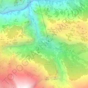
Name: Bulnes de Arriba (El Castillo) topographic map, elevation, terrain.
Average elevation: 1,138 m
Minimum elevation: 235 m
Maximum elevation: 2,324 m
Other topographic maps
Click on a map to view its topography, its elevation and its terrain.
Majada de Ostón
Majada de Ostón, Cabrales, Asturië, 33555, Spanje
Average elevation: 1,105 m
Picos de Europa
Picos de Europa, Cabrales, Asturië, 33554, Spanje
Average elevation: 2,290 m