
Thank you for supporting this site ❤️
Make a donation
Make a donation
Bierer Berg topographic map
Click on the map to display elevation.
Thank you for supporting this site ❤️
Make a donation
Make a donation
Bierer Berg
Auf der eine Höhe von 83 Metern erreichenden baumbestandenen Erhebung befindet sich eine Freilichtbühne, der Heimattiergarten Bierer Berg, ein Aussichtsturm sowie eine Gaststätte. Darüber hinaus besteht ein zu Ehren des Reichskanzlers Otto von Bismarck errichtetes Denkmal. Jeweils im Juli und August eines Jahres wird auf der Freilichtbühne der Schönebecker Operettensommer aufgeführt. Im August findet jährlich das Bierer Berg-Fest statt.
Thank you for supporting this site ❤️
Make a donation
Make a donation
About this map
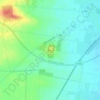
Name: Bierer Berg topographic map, elevation, terrain.
Average elevation: 68 m
Minimum elevation: 53 m
Maximum elevation: 104 m
Thank you for supporting this site ❤️
Make a donation
Make a donation
Other topographic maps
Click on a map to view its topography, its elevation and its terrain.