
Thank you for supporting this site ❤️
Make a donation
Make a donation
Myponga topographic map
Click on the map to display elevation.
Thank you for supporting this site ❤️
Make a donation
Make a donation
About this map
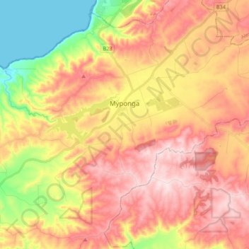
Name: Myponga topographic map, elevation, terrain.
Average elevation: 246 m
Minimum elevation: 0 m
Maximum elevation: 445 m
Thank you for supporting this site ❤️
Make a donation
Make a donation
Other topographic maps
Click on a map to view its topography, its elevation and its terrain.
Myponga River
Australia > South Australia > The District Council of Yankalilla > Myponga > Myponga Beach
Average elevation: 138 m
Kalumunda Forest Reserve
Australia > South Australia > The District Council of Yankalilla
Average elevation: 265 m
Mount Hayfield
Australia > South Australia > The District Council of Yankalilla
Average elevation: 278 m