
Nyaka Sub-County topographic map
Interactive map
Click on the map to display elevation.
About this map
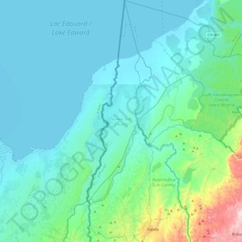
Name: Nyaka Sub-County topographic map, elevation, terrain.
Location: Nyaka Sub-County, Kanungu, Western Region, Ouganda (-0.80723 29.62494 -0.33640 29.75406)
Average elevation: 1,017 m
Minimum elevation: 911 m
Maximum elevation: 1,769 m
Other topographic maps
Click on a map to view its topography, its elevation and its terrain.
Mpungu Sub-County
Mpungu Sub-County, Kanungu, Western Region, Ouganda
Average elevation: 1,716 m
Kayonza Sub-County
Kayonza Sub-County, Kanungu, Western Region, Ouganda
Average elevation: 1,386 m
Kanungu Town Council
Kanungu Town Council, Kanungu, Western Region, Ouganda
Average elevation: 1,639 m