
Thank you for supporting this site ❤️
Make a donation
Make a donation
Gunung Ulin topographic map
Click on the map to display elevation.
Thank you for supporting this site ❤️
Make a donation
Make a donation
About this map
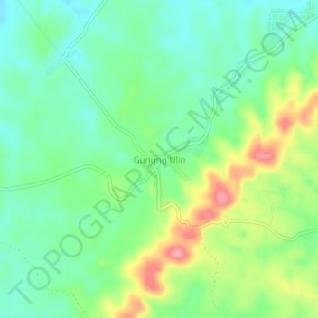
Name: Gunung Ulin topographic map, elevation, terrain.
Location: Gunung Ulin, Banjar, South Kalimantan, Kalimantan, Indonesia (-3.40030 114.94910 -3.36030 114.98910)
Average elevation: 45 m
Minimum elevation: 9 m
Maximum elevation: 114 m
Thank you for supporting this site ❤️
Make a donation
Make a donation
Other topographic maps
Click on a map to view its topography, its elevation and its terrain.
Martapura River
Indonesia > South Kalimantan > Banjar
The watershed area (Indonesian: daerah aliran sungai) of Martapura is 453.88 square kilometers (175.24 sq mi), with the main river length of 36,566 meters (119,967 feet), and with all tributaries has a total length of 375.91 kilometers (233.58 mi), giving a river density level of 0.828 km/km2 (1.333 mi/sq mi).…
Average elevation: 6 m