
Thank you for supporting this site ❤️
Make a donation
Make a donation
Whitehall Corners topographic map
Click on the map to display elevation.
Thank you for supporting this site ❤️
Make a donation
Make a donation
About this map
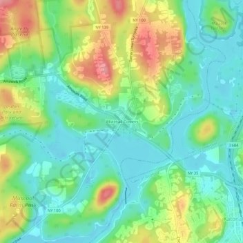
Name: Whitehall Corners topographic map, elevation, terrain.
Average elevation: 97 m
Minimum elevation: 60 m
Maximum elevation: 168 m
Thank you for supporting this site ❤️
Make a donation
Make a donation
Other topographic maps
Click on a map to view its topography, its elevation and its terrain.
Heritage Hills
United States > New York > Westchester County > Town of Somers > Lincolndale
Average elevation: 142 m
Lincolndale
United States > New York > Westchester County > Town of Somers > Lincolndale > Lake Lincolndale
Average elevation: 146 m