
Castiñeiras topographic map
Interactive map
Click on the map to display elevation.
About this map
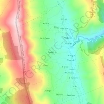
Name: Castiñeiras topographic map, elevation, terrain.
Location: Castiñeiras, Lugo, Galicia, 27278, España (43.04217 -7.29248 43.08217 -7.25248)
Average elevation: 758 m
Minimum elevation: 555 m
Maximum elevation: 1,027 m
Other topographic maps
Click on a map to view its topography, its elevation and its terrain.
Castiñeiras
España > Galicia > Castiñeiras
Castiñeiras, Lugo, Galicia, 27836, España
Average elevation: 624 m