
Amersfoort topographic map
Interactive map
Click on the map to display elevation.
About this map
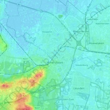
Name: Amersfoort topographic map, elevation, terrain.
Location: Amersfoort, Utrecht, Niederlande (52.10838 5.30646 52.21915 5.47992)
Average elevation: 7 m
Minimum elevation: -3 m
Maximum elevation: 52 m
Other topographic maps
Click on a map to view its topography, its elevation and its terrain.
Hoogland
Niederlande > Utrecht > Amersfoort
Hoogland, Amersfoort, Utrecht, Niederlande
Average elevation: 1 m
Spui
Niederlande > Utrecht > Amersfoort
Spui, Amersfoort, Utrecht, Niederlande, 3811GA, Niederlande
Average elevation: 7 m