
Peasleeville topographic map
Interactive map
Click on the map to display elevation.
About this map
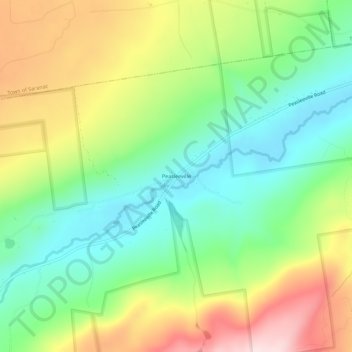
Name: Peasleeville topographic map, elevation, terrain.
Average elevation: 337 m
Minimum elevation: 198 m
Maximum elevation: 551 m
Other topographic maps
Click on a map to view its topography, its elevation and its terrain.
Valcour Island
United States > New York > Clinton County > Town of Peru
Valcour Island, Town of Peru, Town of Plattsburgh, Clinton County, New York, United States
Average elevation: 34 m
Valcour
United States > New York > Clinton County > Town of Peru
Valcour, Town of Peru, Clinton County, New York, United States
Average elevation: 39 m
Peru
United States > New York > Clinton County > Town of Peru
Peru, Town of Peru, Clinton County, New York, 12972, United States
Average elevation: 105 m