
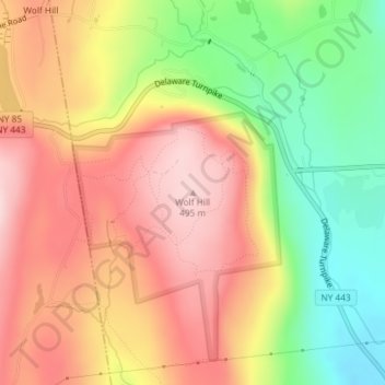
Wolf Hill topographic map
Interactive map
Click on the map to display elevation.
About this map
Name: Wolf Hill topographic map, elevation, terrain.
Average elevation: 385 m
Minimum elevation: 241 m
Maximum elevation: 501 m
Other topographic maps
Click on a map to view its topography, its elevation and its terrain.
Unionville
United States > New York > Albany County > Town of New Scotland
Unionville, Town of New Scotland, Albany County, New York, 12067, United States
Average elevation: 88 m
Clarksville
United States > New York > Albany County > Town of New Scotland
Clarksville, Town of New Scotland, Albany County, New York, 12041, United States
Average elevation: 243 m
Tarrytown
United States > New York > Albany County > Town of New Scotland
Tarrytown, Town of New Scotland, Albany County, New York, 12041, United States
Average elevation: 222 m
New Salem
United States > New York > Albany County > Town of New Scotland
New Salem, Town of New Scotland, Albany County, New York, 12186, United States
Average elevation: 212 m
Feura Bush
United States > New York > Albany County > Town of New Scotland
Feura Bush, Town of New Scotland, Albany County, New York, 12607, United States
Average elevation: 95 m
John Boyd Thacher State Park
United States > New York > Albany County > Town of New Scotland
John Boyd Thacher State Park, Town of New Scotland, Albany County, New York, United States
Average elevation: 262 m
Village of Voorheesville
United States > New York > Albany County > Town of New Scotland
Village of Voorheesville, Town of New Scotland, Albany County, New York, 12186, United States
Average elevation: 107 m