
Thank you for supporting this site ❤️
Make a donation
Make a donation
Dubuque topographic map
Click on the map to display elevation.
Thank you for supporting this site ❤️
Make a donation
Make a donation
About this map
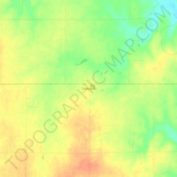
Name: Dubuque topographic map, elevation, terrain.
Location: Dubuque, Barton County, Kansas, United States (38.67584 -98.62896 38.71584 -98.58896)
Average elevation: 572 m
Minimum elevation: 547 m
Maximum elevation: 588 m
Thank you for supporting this site ❤️
Make a donation
Make a donation
Other topographic maps
Click on a map to view its topography, its elevation and its terrain.