
Shantou topographic map
Interactive map
Click on the map to display elevation.
About this map
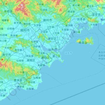
Name: Shantou topographic map, elevation, terrain.
Location: Shantou, Provincia de Cantón, China (22.98757 116.24004 23.64845 117.41973)
Average elevation: 55 m
Minimum elevation: -2 m
Maximum elevation: 1,233 m
Other topographic maps
Click on a map to view its topography, its elevation and its terrain.
Longgang
China > Provincia de Cantón > Longgang
Longgang, Shenzhen, Provincia de Cantón, 518100, China
Average elevation: 72 m
Shenzhen
China > Provincia de Cantón > Shenzhen
Shenzhen, Futian, Shenzhen, Provincia de Cantón, 518000, China
Average elevation: 85 m