Geolocate

Blount County topographic map

Click on the map to display elevation.

Blount County

The southern part of Blount County is part of the Great Smoky Mountains, and is protected by the Great Smoky Mountains National Park. The crest of the range forms the county's border with Swain County, North Carolina, and includes Blount's highest point, 5,527-foot (1,685 m) Thunderhead Mountain, and the 4,949-foot (1,508 m) Gregory Bald, a prominent grassy bald. The northern part of the county is part of the Ridge-and-Valley Appalachians. The geologic boundary between the Blue Ridge (which includes the Smokies) and Ridge-and-Valley provinces runs along Chilhowee Mountain, a long and narrow ridge that stretches across the central part of the county. Much of Blount's topography is characterized by elongate ridges and rolling hills— known locally as "The Foothills"— which emanate outward from the Smokies range.

Wikipedia (CC-BY-SA 3.0)

About this map

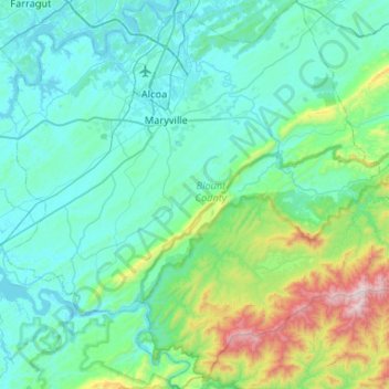
Name: Blount County topographic map, elevation, terrain.

Location: Blount County, East Tennessee, Tennessee, United States (35.46055 -84.18843 35.88713 -83.66320)

Average elevation: 451 m

Minimum elevation: 244 m

Maximum elevation: 1,652 m

Other topographic maps

Click on a map to view its topography, its elevation and its terrain.

Rickman

United States > Tennessee > Overton County

Average elevation: 333 m

Thorn Hill

United States > Tennessee > Grainger County

Average elevation: 474 m

Haletown

United States > Tennessee > Marion County

Average elevation: 286 m

Knoxville

United States > Tennessee > Knox County > Knoxville

Average elevation: 304 m

Hampton

United States > Tennessee > Carter County

Average elevation: 674 m

Piney Flats

United States > Tennessee > Sullivan County

Average elevation: 486 m

Russellville

United States > Tennessee > Hamblen County

Average elevation: 398 m

Graceland

United States > Tennessee > Shelby County > Memphis

Average elevation: 87 m

Lakewood

United States > Tennessee > Davidson County > Nashville

Average elevation: 143 m

Pall Mall

United States > Tennessee > Fentress County

Average elevation: 315 m

Cosby

United States > Tennessee > Cocke County

Average elevation: 483 m

Happy Acres

United States > Tennessee > Knox County

Average elevation: 322 m

Yuma

United States > Tennessee > Carroll County

Average elevation: 144 m

Mayland

United States > Tennessee > Cumberland County

Average elevation: 597 m

Elora

United States > Tennessee > Lincoln County

Average elevation: 294 m

Charity Hill

United States > Tennessee > Carter County

Average elevation: 561 m

Oakland

United States > Tennessee > Wilson County > Lebanon

Average elevation: 160 m

Beech Grove

United States > Tennessee > Cheatham County

Average elevation: 157 m

Summertown

United States > Tennessee > Lawrence County

Average elevation: 301 m

Reliance

United States > Tennessee > Polk County

Average elevation: 307 m

Hambright

United States > Tennessee > Polk County

Average elevation: 351 m

Johntown

United States > Tennessee > Trousdale County

Average elevation: 174 m

Boyce

United States > Tennessee > Hamilton County > Chattanooga

Average elevation: 215 m

Woodstock

United States > Tennessee > Shelby County

Average elevation: 76 m

Woods Valley

United States > Tennessee > Dickson County

Average elevation: 200 m

West Meade

United States > Tennessee > Coffee County > Manchester

Average elevation: 323 m

Melrose

United States > Tennessee > Blount County

Average elevation: 334 m

Scandlyn

United States > Tennessee > Roane County

Average elevation: 302 m

Blair

United States > Tennessee > Roane County

Average elevation: 314 m

Mount Le Conte

United States > Tennessee > Sevier County

Mount Le Conte (or LeConte) is a mountain located within the Great Smoky Mountains National Park in Sevier County, Tennessee. At 6,593 ft (2,010 m) it is the third highest peak in the national park, behind Kuwohi (formerly Clingmans Dome) (6,643 ft (2,025 m)) and Mount Guyot (6,621 ft (2,018 m)). It is also…

Average elevation: 1,661 m

Bucktown

United States > Tennessee > Loudon County > Lenoir City

Average elevation: 258 m

Oak Grove

United States > Tennessee > Henry County

Average elevation: 144 m

Hale

United States > Tennessee > Washington County

Average elevation: 539 m

Bone Cave

United States > Tennessee > Van Buren County

Average elevation: 282 m

Statesville

United States > Tennessee > Wilson County

Average elevation: 255 m

Delano

United States > Tennessee > Polk County

Average elevation: 258 m

Flag Pond

United States > Tennessee > Unicoi County

Average elevation: 846 m

Speedwell

United States > Tennessee > Claiborne County

Average elevation: 416 m

Tallassee

United States > Tennessee > Blount County

Average elevation: 347 m

McDonald

United States > Tennessee > Bradley County

Average elevation: 269 m

Bedford

United States > Tennessee > Bedford County

Average elevation: 239 m

Wilton Springs

United States > Tennessee > Cocke County

Average elevation: 422 m

Beechgrove

United States > Tennessee > Coffee County

Average elevation: 289 m

Bybee

United States > Tennessee > Cocke County

Average elevation: 349 m

Newcomb

United States > Tennessee > Campbell County

Average elevation: 375 m

The Village

United States > Tennessee > Shelby County > Memphis

Average elevation: 94 m

Pine Hills

United States > Tennessee > Roane County > Harriman

Average elevation: 278 m

Pleasantville

United States > Tennessee > Hickman County

Average elevation: 194 m

Only

United States > Tennessee > Hickman County

Average elevation: 161 m

Shiloh

United States > Tennessee > Hardin County

Average elevation: 148 m

Hickory Hills

United States > Tennessee > Bradley County

Average elevation: 257 m

Sharps Chapel

United States > Tennessee > Union County

Average elevation: 362 m

Tellico Dam

United States > Tennessee > Loudon County

Average elevation: 243 m

Normal

United States > Tennessee > Shelby County > Memphis

Average elevation: 93 m

Hearndale

United States > Tennessee > Henry County

Average elevation: 135 m

Ford

United States > Tennessee > Loudon County

Average elevation: 285 m

Riverside

United States > Tennessee > Monroe County

Average elevation: 275 m

Lott Landing

United States > Tennessee > Hardin County

Average elevation: 124 m

Darkey Springs

United States > Tennessee > White County

Average elevation: 298 m