
Oberaula topographic map
Interactive map
Click on the map to display elevation.
About this map
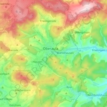
Name: Oberaula topographic map, elevation, terrain.
Location: Oberaula, Schwalm-Eder-Kreis, Hessen, 36280, Duitsland (50.80931 9.40446 50.89504 9.51851)
Average elevation: 412 m
Minimum elevation: 258 m
Maximum elevation: 635 m
Other topographic maps
Click on a map to view its topography, its elevation and its terrain.
Riebelsdorf
Duitsland > Hessen > Schwalm-Eder-Kreis
Riebelsdorf, Neukirchen, Schwalm-Eder-Kreis, Hessen, 34626, Duitsland
Average elevation: 276 m