Thank you for supporting this site ❤️
Make a donation
Make a donation
Cleeve topographic map
Click on the map to display elevation.
Thank you for supporting this site ❤️
Make a donation
Make a donation
About this map
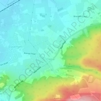
Name: Cleeve topographic map, elevation, terrain.
Location: Cleeve, North Somerset, England, United Kingdom (51.37855 -2.79485 51.40198 -2.75875)
Average elevation: 50 m
Minimum elevation: 3 m
Maximum elevation: 174 m
Thank you for supporting this site ❤️
Make a donation
Make a donation
Other topographic maps
Click on a map to view its topography, its elevation and its terrain.
Weston-super-Mare
United Kingdom > England > North Somerset > Weston-super-Mare
Average elevation: 13 m
Thank you for supporting this site ❤️
Make a donation
Make a donation
Thank you for supporting this site ❤️
Make a donation
Make a donation
Thank you for supporting this site ❤️
Make a donation
Make a donation
Portishead Quays Marina
United Kingdom > England > North Somerset > Portishead > North Weston
Average elevation: 11 m
Thank you for supporting this site ❤️
Make a donation
Make a donation
Thank you for supporting this site ❤️
Make a donation
Make a donation
Thank you for supporting this site ❤️
Make a donation
Make a donation
Thank you for supporting this site ❤️
Make a donation
Make a donation
Thank you for supporting this site ❤️
Make a donation
Make a donation
Thank you for supporting this site ❤️
Make a donation
Make a donation
