
Dranse topographic map
Interactive map
Click on the map to display elevation.
About this map
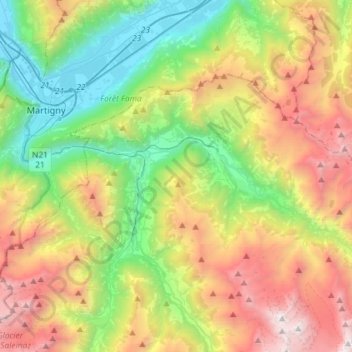
Name: Dranse topographic map, elevation, terrain.
Location: Dranse, Entremont, Wallis, 2303, Schweiz (46.00456 7.05322 46.12591 7.34317)
Average elevation: 1,708 m
Minimum elevation: 449 m
Maximum elevation: 3,697 m
Other topographic maps
Click on a map to view its topography, its elevation and its terrain.
Le Catogne
Schweiz > Wallis > Entremont > Sembrancher
Le Catogne, Sembrancher, Entremont, Wallis, 2303, Schweiz
Average elevation: 1,949 m
Bourg-Saint-Pierre
Bourg-Saint-Pierre, Entremont, Wallis, 1946, Schweiz
Average elevation: 2,530 m
Champex-Lac
Champex-Lac, Orsières, Entremont, Wallis, 2303, Schweiz
Average elevation: 1,552 m