
Make a donation
Bushland topographic map
Click on the map to display elevation.
Make a donation
Bushland
Bushland is located at 35°11′31″N 102°03′53″W / 35.19194°N 102.06472°W / 35.19194; -102.06472 (35.1919978, -102.0646392), at an elevation of 3,825 feet. The community is situated along Interstate 40, approximately 14 miles west of Amarillo in southwestern Potter County.
Make a donation
About this map
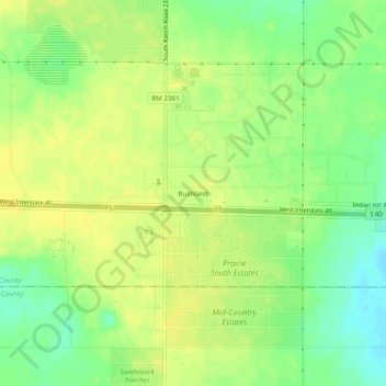
Name: Bushland topographic map, elevation, terrain.
Location: Bushland, Potter County, Texas, 79012, United States (35.17040 -102.08381 35.21040 -102.04381)
Average elevation: 1,167 m
Minimum elevation: 1,154 m
Maximum elevation: 1,175 m
Make a donation
Other topographic maps
Click on a map to view its topography, its elevation and its terrain.
Amarillo
United States > Texas > Potter County
Amarillo features a unique topography characterized by its high elevation and flat plains. The city averages around 3,600 feet (1,097 meters) above sea level, making it one of the highest major cities in Texas. The surrounding landscape consists of the Llano Estacado, a vast tabletop plateau that slopes…
Average elevation: 1,098 m
Amarillo
United States > Texas > Potter County
Extreme temperatures range from −16 °F (−26.7 °C) on February 12, 1899 to 111 °F (43.9 °C) on June 26, 2011, but lows do not typically dip to 0 °F or −17.8 °C in most years, while highs above 100 °F or 37.8 °C are seen on 4.7 days on average. On average, there are 5.9 days of lows at or below 10…
Average elevation: 1,097 m
Amarillo
United States > Texas > Potter County
Extreme temperatures range from −16 °F (−26.7 °C) on February 12, 1899 to 111 °F (43.9 °C) on June 26, 2011, but lows do not typically dip to 0 °F or −17.8 °C in most years, while highs above 100 °F or 37.8 °C are seen on 4.7 days on average. On average, there are 5.9 days of lows at or below 10…
Average elevation: 1,098 m
Make a donation
Amarillo
United States > Texas > Potter County
Extreme temperatures range from −16 °F (−26.7 °C) on February 12, 1899 to 111 °F (43.9 °C) on June 26, 2011, but lows do not typically dip to 0 °F or −17.8 °C in most years, while highs above 100 °F or 37.8 °C are seen on 4.7 days on average. On average, there are 5.9 days of lows at or below 10…
Average elevation: 1,098 m