
Thank you for supporting this site ❤️
Make a donation
Make a donation
Tingkir Tengah topographic map
Click on the map to display elevation.
Thank you for supporting this site ❤️
Make a donation
Make a donation
About this map
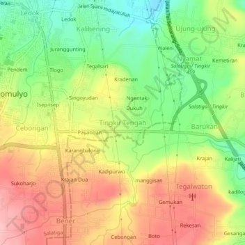
Name: Tingkir Tengah topographic map, elevation, terrain.
Average elevation: 673 m
Minimum elevation: 599 m
Maximum elevation: 745 m
Thank you for supporting this site ❤️
Make a donation
Make a donation
Other topographic maps
Click on a map to view its topography, its elevation and its terrain.
Gantangan Burung Bung Karno Dukuh Salatiga
Indonesia > Central Java > Salatiga > Dukuh > Glogolan
Average elevation: 599 m