
Thank you for supporting this site ❤️
Make a donation
Make a donation
Seale topographic map
Click on the map to display elevation.
Thank you for supporting this site ❤️
Make a donation
Make a donation
About this map
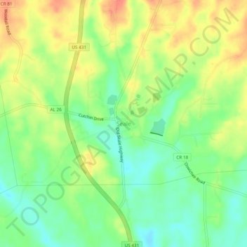
Name: Seale topographic map, elevation, terrain.
Location: Seale, Russell County, Alabama, 36875, United States (32.27737 -85.18883 32.31737 -85.14883)
Average elevation: 112 m
Minimum elevation: 88 m
Maximum elevation: 138 m
Thank you for supporting this site ❤️
Make a donation
Make a donation
Other topographic maps
Click on a map to view its topography, its elevation and its terrain.