
Thank you for supporting this site ❤️
Make a donation
Make a donation
Isola di Stromboli topographic map
Click on the map to display elevation.
Thank you for supporting this site ❤️
Make a donation
Make a donation
About this map
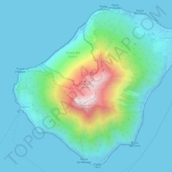
Name: Isola di Stromboli topographic map, elevation, terrain.
Location: Isola di Stromboli, Lipari, Messina, Sicily, Italy (38.77161 15.18732 38.81198 15.24324)
Average elevation: 160 m
Minimum elevation: 0 m
Maximum elevation: 914 m
Thank you for supporting this site ❤️
Make a donation
Make a donation
Other topographic maps
Click on a map to view its topography, its elevation and its terrain.