
Thank you for supporting this site ❤️
Make a donation
Make a donation
Susten topographic map
Click on the map to display elevation.
Thank you for supporting this site ❤️
Make a donation
Make a donation
About this map
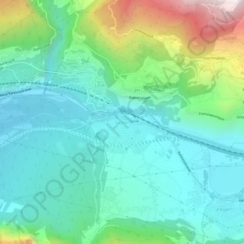
Name: Susten topographic map, elevation, terrain.
Location: Susten, Leuk, Wallis, 3952, Switzerland (46.29093 7.62064 46.33093 7.66064)
Average elevation: 832 m
Minimum elevation: 572 m
Maximum elevation: 1,626 m
Thank you for supporting this site ❤️
Make a donation
Make a donation
Other topographic maps
Click on a map to view its topography, its elevation and its terrain.
Albinen
Switzerland > Wallis > Leuk
The flora changes with the different altitudes of the territory. The lower areas are dominated by woods and meadows. The countryside changes to mountain meadows, rocks and cliffs at the higher altitudes. A large variety of wild flowers can be found, especially during spring and in the early summer when most of…
Average elevation: 1,698 m