
Thank you for supporting this site ❤️
Make a donation
Make a donation
Gößnitz topographic map
Click on the map to display elevation.
Thank you for supporting this site ❤️
Make a donation
Make a donation
About this map
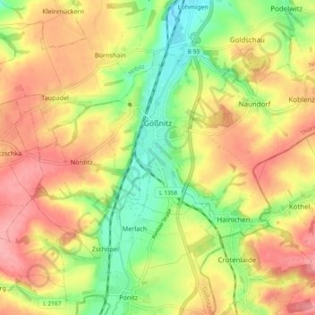
Name: Gößnitz topographic map, elevation, terrain.
Location: Gößnitz, Altenburger Land, Thüringen, 04639, Deutschland (50.86210 12.39611 50.90323 12.48819)
Average elevation: 248 m
Minimum elevation: 198 m
Maximum elevation: 292 m
Thank you for supporting this site ❤️
Make a donation
Make a donation
Other topographic maps
Click on a map to view its topography, its elevation and its terrain.
Steinsdorf
Deutschland > Thüringen > Altenburger Land > Schmölln > Burkersdorf
Average elevation: 255 m
Thank you for supporting this site ❤️
Make a donation
Make a donation
Thank you for supporting this site ❤️
Make a donation
Make a donation
Thank you for supporting this site ❤️
Make a donation
Make a donation