
Thank you for supporting this site ❤️
Make a donation
Make a donation
Villeneuve Lembron topographic map
Click on the map to display elevation.
Thank you for supporting this site ❤️
Make a donation
Make a donation
About this map
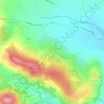
Name: Villeneuve Lembron topographic map, elevation, terrain.
Average elevation: 516 m
Minimum elevation: 421 m
Maximum elevation: 707 m
Thank you for supporting this site ❤️
Make a donation
Make a donation
Other topographic maps
Click on a map to view its topography, its elevation and its terrain.
Château de Villeneuve-Lembron
France > Auvergne-Rhône-Alpes > Puy-de-Dôme > Villeneuve > Villeneuve Lembron
Average elevation: 522 m