
Make a donation
Gallina topographic map
Click on the map to display elevation.
Make a donation
About this map
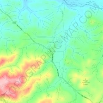
Name: Gallina topographic map, elevation, terrain.
Average elevation: 325 m
Minimum elevation: 271 m
Maximum elevation: 432 m
Make a donation
Other topographic maps
Click on a map to view its topography, its elevation and its terrain.
Make a donation
San Gimignano
The municipality of San Gimignano extends for 138 km² and is located on a hill in Val d'Elsa. The altitude difference is between a minimum of 64 meters a.s.l. in the plain of the river Elsa near Certaldo at a maximum of 631 meters in the area of Cornocchio.
Average elevation: 239 m
Make a donation
Make a donation
Make a donation
Make a donation
Make a donation