
Thank you for supporting this site ❤️
Make a donation
Make a donation
Macbeth topographic map
Click on the map to display elevation.
Thank you for supporting this site ❤️
Make a donation
Make a donation
About this map
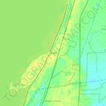
Name: Macbeth topographic map, elevation, terrain.
Location: Macbeth, Berkeley County, South Carolina, United States (33.24767 -79.99480 33.28767 -79.95480)
Average elevation: 19 m
Minimum elevation: 6 m
Maximum elevation: 29 m
Thank you for supporting this site ❤️
Make a donation
Make a donation
Other topographic maps
Click on a map to view its topography, its elevation and its terrain.
Thank you for supporting this site ❤️
Make a donation
Make a donation
Thank you for supporting this site ❤️
Make a donation
Make a donation
Thank you for supporting this site ❤️
Make a donation
Make a donation