
Thank you for supporting this site ❤️
Make a donation
Make a donation
Ramsey Springs topographic map
Click on the map to display elevation.
Thank you for supporting this site ❤️
Make a donation
Make a donation
About this map
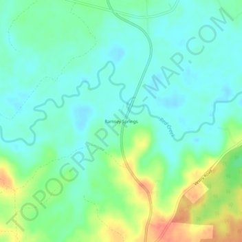
Name: Ramsey Springs topographic map, elevation, terrain.
Location: Ramsey Springs, Stone County, Mississippi, United States (30.75075 -88.93476 30.79075 -88.89476)
Average elevation: 31 m
Minimum elevation: 16 m
Maximum elevation: 64 m
Thank you for supporting this site ❤️
Make a donation
Make a donation
Other topographic maps
Click on a map to view its topography, its elevation and its terrain.