
Perry Green topographic map
Click on the map to display elevation.
About this map
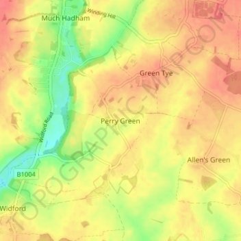
Name: Perry Green topographic map, elevation, terrain.
Average elevation: 78 m
Minimum elevation: 44 m
Maximum elevation: 98 m
Other topographic maps
Click on a map to view its topography, its elevation and its terrain.
Astonbury Wood
United Kingdom > England > Hertfordshire > East Hertfordshire > Aston
Average elevation: 83 m
Thorley
United Kingdom > England > Hertfordshire > East Hertfordshire > Thorley
Average elevation: 82 m
Sawbridgeworth
United Kingdom > England > Hertfordshire > East Hertfordshire > Sawbridgeworth
Average elevation: 67 m
Standon
United Kingdom > England > Hertfordshire > East Hertfordshire > Standon
Average elevation: 97 m
Bishop's Stortford
United Kingdom > England > Hertfordshire > East Hertfordshire > Thorley
Stortford, along with the rest of Britain, has a temperate maritime climate, with cool summers and mild winters. The nearest weather station for which averages and extremes are available is Stansted Airport, about 2+1⁄2 miles (4 kilometres) due east of Stortford's town centre. Located at an elevation of over…
Average elevation: 83 m
King's Meads
United Kingdom > England > Hertfordshire > East Hertfordshire > Ware
Average elevation: 53 m
Furneux Pelham
United Kingdom > England > Hertfordshire > East Hertfordshire > Furneux Pelham
Average elevation: 113 m
Thundridge
United Kingdom > England > Hertfordshire > East Hertfordshire > High Cross
Average elevation: 78 m
Stocking Pelham
United Kingdom > England > Hertfordshire > East Hertfordshire > Stocking Pelham
Average elevation: 114 m
Little Berkhamsted
United Kingdom > England > Hertfordshire > East Hertfordshire
Average elevation: 88 m
Datchworth
United Kingdom > England > Hertfordshire > East Hertfordshire > Datchworth
Average elevation: 102 m
Buntingford
United Kingdom > England > Hertfordshire > East Hertfordshire > Buntingford
Average elevation: 110 m
Widford
United Kingdom > England > Hertfordshire > East Hertfordshire > Widford
Average elevation: 73 m
Hertford Heath Nature Reserve
United Kingdom > England > Hertfordshire > East Hertfordshire > Hertford Heath
Average elevation: 79 m
Stocking Pelham
United Kingdom > England > Hertfordshire > East Hertfordshire
Average elevation: 114 m
Buntingford
United Kingdom > England > Hertfordshire > East Hertfordshire > Buntingford
Average elevation: 110 m
Hertford Lock No 1
United Kingdom > England > Hertfordshire > East Hertfordshire > Hertford
Average elevation: 53 m
Braughing
United Kingdom > England > Hertfordshire > East Hertfordshire > Braughing
Average elevation: 104 m
Sawbridgeworth
United Kingdom > England > Hertfordshire > East Hertfordshire > Sawbridgeworth
Average elevation: 67 m