
淡水區 topographic map
Interactive map
Click on the map to display elevation.
About this map
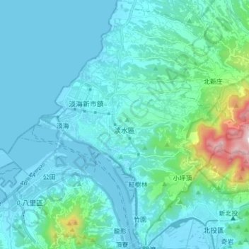
Name: 淡水區 topographic map, elevation, terrain.
Location: 淡水區, 新北市, 臺灣 (25.12291 121.39573 25.24440 121.52258)
Average elevation: 120 m
Minimum elevation: -3 m
Maximum elevation: 1,014 m
Other topographic maps
Click on a map to view its topography, its elevation and its terrain.
淡水河口-台北港-林口火力發電廠、西海岸、夕陽落海、賞鷹平台
淡水河口-台北港-林口火力發電廠、西海岸、夕陽落海、賞鷹平台, 牛港稜步道, 舊城里, 八里區, 新北市, 249, 臺灣
Average elevation: 230 m