
Make a donation
Hamblin topographic map
Click on the map to display elevation.
Make a donation
About this map
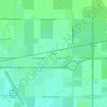
Name: Hamblin topographic map, elevation, terrain.
Location: Hamblin, Kings County, California, 93230, United States (36.30967 -119.62985 36.34967 -119.58985)
Average elevation: 76 m
Minimum elevation: 71 m
Maximum elevation: 81 m
Make a donation
Other topographic maps
Click on a map to view its topography, its elevation and its terrain.
Corcoran
United States > California > Kings County
Corcoran is a city in Kings County, California, United States. The population was 24,813 (2010 census), up from 14,458 (2000 census). Corcoran is located 17 miles (27 km) south-southeast of Hanford, at an elevation of 207 ft (63 m).
Average elevation: 62 m
Lemoore
United States > California > Kings County
Lemoore (/ləˈmɔːr/ lə-MOR; formerly La Tache and Lee Moore's) is a city in Kings County, California, United States. Lemoore is located 7.5 miles (12 km) west-southwest of Hanford, at an elevation of 230 feet (70 m). It is part of the Hanford-Corcoran Metropolitan Statistical Area (MSA Code 25260). The…
Average elevation: 66 m
Lemoore
United States > California > Kings County
Lemoore (formerly, La Tache and Lee Moore's) is a city in Kings County, California, United States. Lemoore is located 7.5 miles (12 km) west-southwest of Hanford, at an elevation of 230 feet (70 m). It is part of the Hanford-Corcoran Metropolitan Statistical Area (MSA Code 25260). The population was 24,531 at…
Average elevation: 66 m
Tulare Lake
United States > California > Kings County
It was separated from the rest of the San Joaquin Valley by tectonic subsidence and alluvial fans extending out from Los Gatos Creek in the Coast Ranges and the Kings River in the Sierra Nevada. Above a threshold elevation of 207 to 210 feet (63 to 64 m), it overflowed northward into the then-extant Summit…
Average elevation: 59 m
Make a donation
Corcoran
United States > California > Kings County
Corcoran is a city in Kings County, California. Corcoran is located 17 miles (27 km) south-southeast of Hanford, at an elevation of 207 ft (63 m). It is part of the Hanford–Corcoran Metropolitan Statistical Area. The population was 24,813 (2010 census), up from 14,458 (2000 census). The California Department…
Average elevation: 62 m
Armona
United States > California > Kings County > Armona
Armona is a census-designated place (CDP) in Kings County, California, United States. Armona is located 3.5 miles (5.6 km) west-southwest of Hanford, at an elevation of 239 feet (73 m). It is part of the Hanford–Corcoran Metropolitan Statistical Area. The population was 4,156 at the 2010 census. Armona's…
Average elevation: 70 m