
Thank you for supporting this site ❤️
Make a donation
Make a donation
Bonnyrigg topographic map
Click on the map to display elevation.
Thank you for supporting this site ❤️
Make a donation
Make a donation
About this map
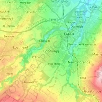
Name: Bonnyrigg topographic map, elevation, terrain.
Location: Bonnyrigg, Midlothian, Scotland, EH19 2DA, United Kingdom (55.83512 -3.14591 55.91512 -3.06591)
Average elevation: 114 m
Minimum elevation: 25 m
Maximum elevation: 257 m
Thank you for supporting this site ❤️
Make a donation
Make a donation
Other topographic maps
Click on a map to view its topography, its elevation and its terrain.
Straiton Pond Local Nature Reserve
United Kingdom > Scotland > Midlothian > Loanhead
Average elevation: 131 m