
Thank you for supporting this site ❤️
Make a donation
Make a donation
Faro di Punta Filetto topographic map
Click on the map to display elevation.
Thank you for supporting this site ❤️
Make a donation
Make a donation
About this map
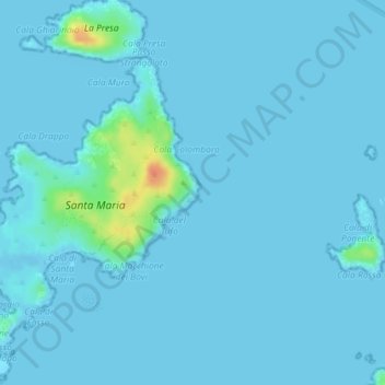
Name: Faro di Punta Filetto topographic map, elevation, terrain.
Average elevation: 3 m
Minimum elevation: -2 m
Maximum elevation: 44 m
Thank you for supporting this site ❤️
Make a donation
Make a donation
Other topographic maps
Click on a map to view its topography, its elevation and its terrain.
Arcipelago di La Maddalena
Italia > Sardegna > Gallura Nord-Est Sardegna > La Maddalena
Average elevation: 37 m