
Otero County topographic map
Interactive map
Click on the map to display elevation.
About this map
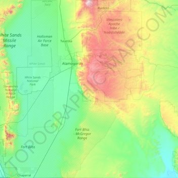
Name: Otero County topographic map, elevation, terrain.
Location: Otero County, Novo México, Estados Unidos da América (32.00012 -106.37743 33.39069 -104.84766)
Average elevation: 1,595 m
Minimum elevation: 1,101 m
Maximum elevation: 3,542 m
Other topographic maps
Click on a map to view its topography, its elevation and its terrain.
Alamogordo
Estados Unidos da América > Novo México > Otero County
Alamogordo, Otero County, Novo México, 88310, Estados Unidos da América
Average elevation: 1,644 m