
Make a donation
Pompano Beach topographic map
Click on the map to display elevation.
Make a donation
Pompano Beach
Pompano Beach features a low-elevation coastal landscape typical of southeastern Florida. With an average elevation around 20 feet above sea level, the area is flat, gradually sloping toward the Atlantic Ocean to the east. The terrain includes a blend of sandy beach areas along the coast and slightly higher, well-drained inland regions that were once part of Florida’s original wetlands. Its flat topography and proximity to the ocean make it susceptible to flooding, particularly in low-lying areas, a challenge that has shaped both its residential zoning and environmental planning efforts, especially concerning stormwater management and conservation of natural water flow.
Make a donation
About this map
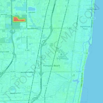
Name: Pompano Beach topographic map, elevation, terrain.
Location: Pompano Beach, Broward County, Florida, United States (26.20598 -80.19561 26.29766 -80.08134)
Average elevation: 6 m
Minimum elevation: 0 m
Maximum elevation: 45 m
Make a donation
Other topographic maps
Click on a map to view its topography, its elevation and its terrain.
Make a donation
Ro-Len Lake Gardens
United States > Florida > Broward County > Hallandale Beach
Average elevation: 7 m
Bonita Bay
United States > Florida > Broward County > Fort Lauderdale > Soroka Shores
Average elevation: 4 m
Make a donation
Make a donation
Make a donation
Make a donation
Make a donation
Make a donation
Make a donation
Bonita Bay
United States > Florida > Broward County > Fort Lauderdale > Soroka Shores
Average elevation: 4 m
Make a donation
Fort Lauderdale Beach
United States > Florida > Broward County > Fort Lauderdale > Birch Ocean Front
Average elevation: 3 m