Geolocate

Cantabria topographic map

Interactive map

Click on the map to display elevation.

Cantabria

Towards the south are higher mountains, the tops of which form the watershed between the drainage basins of the Rivers Ebro, Duero and the rivers that flow into the Bay of Biscay. These peaks generally exceed 1,500 m (4,900 ft) from the Pass of San Glorio in the west to the Pass of Los Tornos in the eastern part: Peña Labra, Castro Valnera and the mountain passes of Sejos, El Escudo and La Sía. The great limestone masses of Picos de Europa also stand out in the southwest of the region: most of their summits exceed 2,500 m (8,200 ft), and their topography is shaped by the former presence of glaciers.

Wikipedia (CC-BY-SA 3.0)

About this map

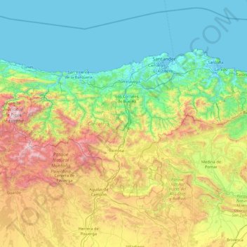
Name: Cantabria topographic map, elevation, terrain.

Location: Cantabria, Spain (42.75805 -4.85174 43.51362 -3.14965)

Average elevation: 609 m

Minimum elevation: -3 m

Maximum elevation: 2,603 m

Other topographic maps

Click on a map to view its topography, its elevation and its terrain.

Barcelona

Spain > Catalonia > Barcelonès > Barcelona

Average elevation: 65 m

Rícmar

Spain > Andalusia > Costa del Sol Occidental > Marbella

Average elevation: 35 m

Bel-Air

Spain > Andalusia > Costa del Sol Occidental > Estepona

Average elevation: 35 m

Pimiango

Spain > Asturias > Ribadedeva

Average elevation: 56 m

Los Solaines

Spain > Valencian Community > Villena

Average elevation: 690 m

Priédamu

Spain > Asturias > Llanes

Average elevation: 422 m

Arnao

Spain > Castrillón > Piedrasblancas

Average elevation: 25 m

Mondrón

Spain > Andalusia > La Axarquía > Periana

Average elevation: 576 m

Ganbella

Spain > Pirinioaurrea / Prepirineo > Unciti

Average elevation: 948 m

Cortiguera

Spain > Castile and León > El Bierzo

Average elevation: 552 m

Pico Mazo

Spain > Castile and León > Valle de Sedano

Average elevation: 802 m

Praia de Queiruga

Spain > Galicia > Noia > As Chamosas

Average elevation: 45 m

Mazapé

Spain > Santa Cruz de Tenerife

Average elevation: 321 m

Refugi de la Restanca

Spain > Catalonia > Val d'Aran

Average elevation: 2,161 m

Somport

Spain > Aragon > Aísa

Average elevation: 1,727 m

Carrascal

Spain > Navarre > Urraul Alto

Average elevation: 970 m

León

Spain > Castile and León > León

Average elevation: 838 m

Vargas

Spain > Rioja > Ajamil

Average elevation: 1,167 m