
Thank you for supporting this site ❤️
Make a donation
Make a donation
Windeck topographic map
Click on the map to display elevation.
Thank you for supporting this site ❤️
Make a donation
Make a donation
About this map
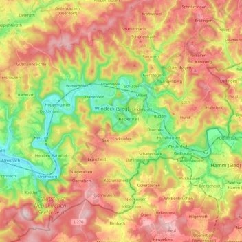
Name: Windeck topographic map, elevation, terrain.
Average elevation: 237 m
Minimum elevation: 85 m
Maximum elevation: 387 m
Thank you for supporting this site ❤️
Make a donation
Make a donation
Other topographic maps
Click on a map to view its topography, its elevation and its terrain.
Breitscheid
Germany > North Rhine-Westphalia > Rhein-Sieg-Kreis > Neunkirchen-Seelscheid
Average elevation: 179 m
Thank you for supporting this site ❤️
Make a donation
Make a donation
Pinn
Germany > North Rhine-Westphalia > Rhein-Sieg-Kreis > Neunkirchen-Seelscheid > Remschoß
Average elevation: 169 m
Thank you for supporting this site ❤️
Make a donation
Make a donation
Niederhalberg
Germany > North Rhine-Westphalia > Rhein-Sieg-Kreis > Hennef (Sieg) > Niederhalberg
Average elevation: 144 m
Uthweiler
Germany > North Rhine-Westphalia > Rhein-Sieg-Kreis > Königswinter > Uthweiler
Average elevation: 157 m
Heisterbacherrott
Germany > North Rhine-Westphalia > Rhein-Sieg-Kreis > Königswinter
Average elevation: 211 m