
Thank you for supporting this site ❤️
Make a donation
Make a donation
San Marzanotto topographic map
Click on the map to display elevation.
Thank you for supporting this site ❤️
Make a donation
Make a donation
About this map
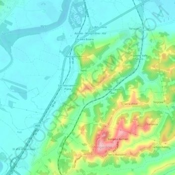
Name: San Marzanotto topographic map, elevation, terrain.
Location: San Marzanotto, Asti, Piemonte, 14100, Italia (44.84278 8.19384 44.88278 8.23384)
Average elevation: 153 m
Minimum elevation: 105 m
Maximum elevation: 288 m
Thank you for supporting this site ❤️
Make a donation
Make a donation
Other topographic maps
Click on a map to view its topography, its elevation and its terrain.