
Oaxtepec topographic map
Interactive map
Click on the map to display elevation.
About this map
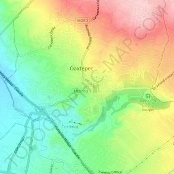
Name: Oaxtepec topographic map, elevation, terrain.
Location: Oaxtepec, Yautepec, Morelos, 62738, México (18.87056 -99.01200 18.95056 -98.93200)
Average elevation: 1,413 m
Minimum elevation: 1,252 m
Maximum elevation: 1,859 m
Other topographic maps
Click on a map to view its topography, its elevation and its terrain.