
Thank you for supporting this site ❤️
Make a donation
Make a donation
Kermon topographic map
Click on the map to display elevation.
Thank you for supporting this site ❤️
Make a donation
Make a donation
About this map
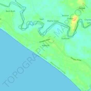
Name: Kermon topographic map, elevation, terrain.
Location: Kermon, St. Paul River, Montserrado County, Liberia (6.45241 -10.88992 6.49241 -10.84992)
Average elevation: 6 m
Minimum elevation: 0 m
Maximum elevation: 24 m
Thank you for supporting this site ❤️
Make a donation
Make a donation
Other topographic maps
Click on a map to view its topography, its elevation and its terrain.