
Thank you for supporting this site ❤️
Make a donation
Make a donation
Gurla Mandhata topographic map
Click on the map to display elevation.
Thank you for supporting this site ❤️
Make a donation
Make a donation
Gurla Mandhata
In 1905, T. G. Longstaff made an attempt on the west face of Gurla Mandhata with two alpine guides and six porters. After suffering a 900 feet (270 m) fall during an avalanche, they turned back around 7,000 m (23,000 ft) upon finding fresh snow was falling too heavily to reach the summit with their provisions. This was a strong achievement for the time, especially for such a small group; at that time no summit of over 7,000 m had yet been climbed and Longstaff's height represented a world altitude record.
Thank you for supporting this site ❤️
Make a donation
Make a donation
About this map
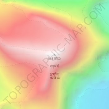
Name: Gurla Mandhata topographic map, elevation, terrain.
Average elevation: 6,913 m
Minimum elevation: 5,852 m
Maximum elevation: 7,676 m
Thank you for supporting this site ❤️
Make a donation
Make a donation