
Make a donation
Zagajica topographic map
Click on the map to display elevation.
Make a donation
About this map
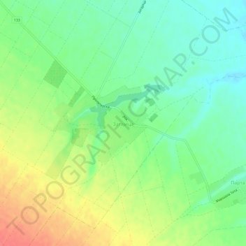
Name: Zagajica topographic map, elevation, terrain.
Average elevation: 109 m
Minimum elevation: 85 m
Maximum elevation: 142 m
Make a donation
Other topographic maps
Click on a map to view its topography, its elevation and its terrain.
Veliki Gaj
Serbia > Vojvodina > South Banat Administrative District > Plandiste Municipality
Average elevation: 84 m
Ilandza
Serbia > Vojvodina > South Banat Administrative District > Alibunar Municipality
Average elevation: 83 m
Make a donation
Jermenovci
Serbia > Vojvodina > South Banat Administrative District > Plandiste Municipality
Average elevation: 77 m
Kovin
Serbia > Vojvodina > South Banat Administrative District > Kovin Municipality
Average elevation: 74 m
Barice
Serbia > Vojvodina > South Banat Administrative District > Plandiste Municipality
Average elevation: 78 m
Margita
Serbia > Vojvodina > South Banat Administrative District > Plandiste Municipality
Average elevation: 80 m
Make a donation
Kovin
Serbia > Vojvodina > South Banat Administrative District > Kovin Municipality
Average elevation: 74 m
Nikolinci
Serbia > Vojvodina > South Banat Administrative District > Alibunar Municipality
Average elevation: 118 m
Bela Crkva Municipality
Serbia > Vojvodina > South Banat Administrative District
Average elevation: 124 m
Make a donation