Geolocate

Posada de Llanera topographic map

Interactive map

Click on the map to display elevation.

About this map

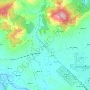
Name: Posada de Llanera topographic map, elevation, terrain.

Location: Posada de Llanera, Llanera, Asturias, 33424, España (43.42027 -5.87133 43.46027 -5.83133)

Average elevation: 207 m

Minimum elevation: 128 m

Maximum elevation: 429 m

Other topographic maps

Click on a map to view its topography, its elevation and its terrain.

Santolaya / Soto de Llanera

España > Asturias > Llanera > Santolaya / Soto de Llanera

Santolaya / Soto de Llanera, Llanera, Asturias, 33423, España

Average elevation: 203 m

Verdera

España > Asturias > Llanera

Verdera, Llanera, Asturias, 33406, España

Average elevation: 271 m

Prubia

España > Asturias > Llanera > Santolaya / Soto de Llanera > Prubia de Abajo

Prubia, Prubia de Abajo, Santolaya / Soto de Llanera, Llanera, Asturias, 33423, España

Average elevation: 198 m

Albite

España > Asturias > Llanera

Albite, Llanera, Asturias, 33424, España

Average elevation: 217 m

Gorfolí

España > Asturias > Llanera

Gorfolí, Llanera, Asturias, 33411, España

Average elevation: 345 m