
Lake McConaughy topographic map
Interactive map
Click on the map to display elevation.
About this map
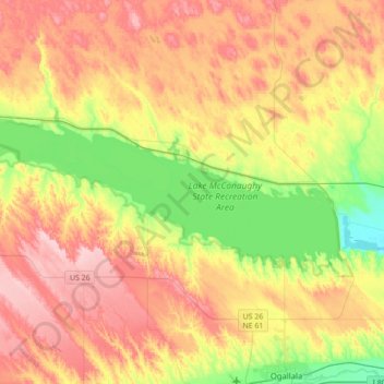
Name: Lake McConaughy topographic map, elevation, terrain.
Location: Lake McConaughy, Keith County, Nebraska, United States (41.19730 -102.01692 41.30292 -101.66904)
Average elevation: 1,048 m
Minimum elevation: 947 m
Maximum elevation: 1,150 m
Other topographic maps
Click on a map to view its topography, its elevation and its terrain.
Keystone
United States > Nebraska > Keith County
Keystone, Keith County, Nebraska, 69144, United States
Average elevation: 949 m
Brule
United States > Nebraska > Keith County
Brule, Keith County, Nebraska, United States
Average elevation: 1,008 m
Ogallala
United States > Nebraska > Keith County
Ogallala, Keith County, Nebraska, 69153, United States
Average elevation: 1,008 m