
Thank you for supporting this site ❤️
Make a donation
Make a donation
New Deal topographic map
Click on the map to display elevation.
Thank you for supporting this site ❤️
Make a donation
Make a donation
About this map
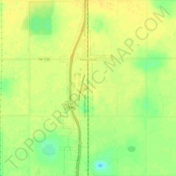
Name: New Deal topographic map, elevation, terrain.
Location: New Deal, Lubbock County, Texas, 79350, United States (33.70837 -101.84505 33.75197 -101.82947)
Average elevation: 1,004 m
Minimum elevation: 987 m
Maximum elevation: 1,012 m
Thank you for supporting this site ❤️
Make a donation
Make a donation
Other topographic maps
Click on a map to view its topography, its elevation and its terrain.
Shallowater
United States > Texas > Lubbock County > Shallowater > Shallowater
Average elevation: 1,009 m