
Laubary topographic map
Interactive map
Click on the map to display elevation.
About this map
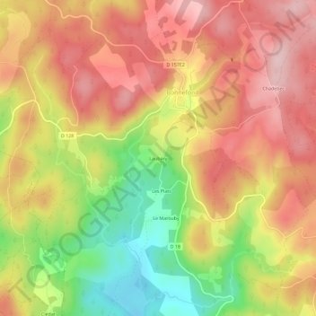
Name: Laubary topographic map, elevation, terrain.
Average elevation: 821 m
Minimum elevation: 680 m
Maximum elevation: 923 m
Other topographic maps
Click on a map to view its topography, its elevation and its terrain.
La Naucodie
France > Nouvelle-Aquitaine > Corrèze > Bonnefond
La Naucodie, Bonnefond, Tulle, Corrèze, Nouvelle-Aquitaine, France métropolitaine, 19170, France
Average elevation: 843 m
La Nouaille
France > Nouvelle-Aquitaine > Corrèze > Bonnefond
La Nouaille, Bonnefond, Tulle, Corrèze, Nouvelle-Aquitaine, France métropolitaine, 19170, France
Average elevation: 806 m