
Make a donation
Westerhausen topographic map
Click on the map to display elevation.
Make a donation
About this map
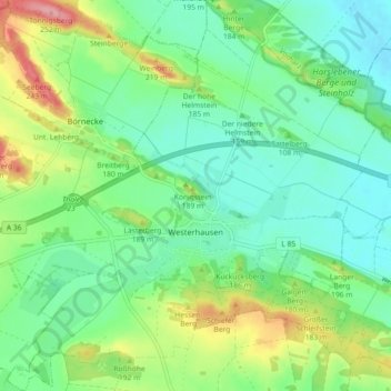
Name: Westerhausen topographic map, elevation, terrain.
Average elevation: 159 m
Minimum elevation: 122 m
Maximum elevation: 242 m
Make a donation
Other topographic maps
Click on a map to view its topography, its elevation and its terrain.
Hexentanzplatz
Deutschland > Sachsen-Anhalt > Landkreis Harz > Thale
Über den Hexentanzplatz ziehen sich Reste des Sachsenwalles. Dabei handelt es sich um eine 150 m lange Trockenmauer aus Granitsteinen von einst 2 m Höhe. Sie wurde etwa 750 bis 450 v. Chr. errichtet. Die Mauer schirmte Teile des erhöhten Geländes des Hexentanzplatzes ab und diente vermutlich als Fliehburg.
Average elevation: 379 m
Bodetal
Deutschland > Sachsen-Anhalt > Landkreis Harz > Thale
Ein zehn Kilometer langer Wanderweg erschließt die Bodeschlucht zwischen Thale und Treseburg. An Engstellen wird der Weg in steilen Kehren und als Fußpfad über Felsen geführt. Von dort ergeben sich hervorragende Ausblicke in die Schlucht. Zuwegungen ins Tal gehen von den Aussichtsfelsen an Roßtrappe und…
Average elevation: 390 m
Hexentanzplatz
Deutschland > Sachsen-Anhalt > Landkreis Harz > Thale
Über den Hexentanzplatz ziehen sich Reste des Sachsenwalles. Dabei handelt es sich um eine 150 m lange Trockenmauer aus Granitsteinen von einst 2 m Höhe. Sie wurde etwa 750 bis 450 v. Chr. errichtet. Die Mauer schirmte Teile des erhöhten Geländes des Hexentanzplatzes ab und diente vermutlich als Fliehburg.
Average elevation: 397 m
Make a donation