
Maspalomas topographic map
Interactive map
Click on the map to display elevation.
About this map
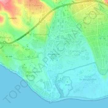
Name: Maspalomas topographic map, elevation, terrain.
Average elevation: 53 m
Minimum elevation: 0 m
Maximum elevation: 312 m
Trotzdem hebt sich Playa del Inglés von vergleichbaren spanischen Massentourismuszielen wie beispielsweise Benidorm oder Torremolinos immer noch positiv durch eine deutlich geringere Bebauungsdichte und eine geringere Bauhöhe ab.