
Thank you for supporting this site ❤️
Make a donation
Make a donation
Taufkirchen an der Pram topographic map
Click on the map to display elevation.
Thank you for supporting this site ❤️
Make a donation
Make a donation
Taufkirchen an der Pram
Taufkirchen an der Pram liegt auf 338 m Höhe im Innviertel. Die Ausdehnung beträgt von Nord nach Süd 7,9 km, von West nach Ost 6 km. Die Gesamtfläche beträgt 29,2 km², 11,6 % der Fläche sind bewaldet, 78,8 % der Fläche sind landwirtschaftlich genutzt.
Thank you for supporting this site ❤️
Make a donation
Make a donation
About this map
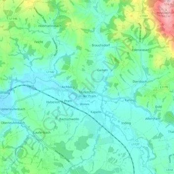
Name: Taufkirchen an der Pram topographic map, elevation, terrain.
Average elevation: 371 m
Minimum elevation: 317 m
Maximum elevation: 569 m
Thank you for supporting this site ❤️
Make a donation
Make a donation
Other topographic maps
Click on a map to view its topography, its elevation and its terrain.
Stocket
Österreich > Oberösterreich > Bezirk Schärding > St. Marienkirchen bei Schärding
Average elevation: 332 m
Thank you for supporting this site ❤️
Make a donation
Make a donation
Atzmanning
Österreich > Oberösterreich > Bezirk Schärding > Brunnenthal > Atzmanning
Average elevation: 456 m
Thank you for supporting this site ❤️
Make a donation
Make a donation