
Târgu Mureș topographic map
Interactive map
Click on the map to display elevation.
About this map
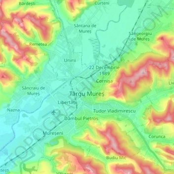
Name: Târgu Mureș topographic map, elevation, terrain.
Location: Târgu Mureș, Zona Metropolitană Târgu Mureș, Mureș, Roumanie (46.50002 24.49187 46.59617 24.62685)
Average elevation: 357 m
Minimum elevation: 296 m
Maximum elevation: 486 m
Other topographic maps
Click on a map to view its topography, its elevation and its terrain.
Sighișoara
Roumanie > Mureș > Sighișoara > Sighișoara
Sighișoara, Mureș, Roumanie
Average elevation: 422 m
Gheorghe Doja
Gheorghe Doja, Zona Metropolitană Târgu Mureș, Mureș, Roumanie
Average elevation: 360 m