
Thank you for supporting this site ❤️
Make a donation
Make a donation
Halden topographic map
Click on the map to display elevation.
Thank you for supporting this site ❤️
Make a donation
Make a donation
About this map
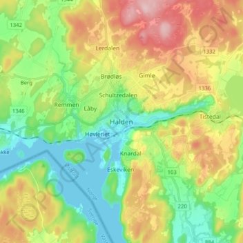
Name: Halden topographic map, elevation, terrain.
Location: Halden, Østfold, 1776, Norge (59.08457 11.34773 59.16457 11.42773)
Average elevation: 82 m
Minimum elevation: -1 m
Maximum elevation: 211 m
Thank you for supporting this site ❤️
Make a donation
Make a donation
Other topographic maps
Click on a map to view its topography, its elevation and its terrain.