
Thank you for supporting this site ❤️
Make a donation
Make a donation
Thourio topographic map
Click on the map to display elevation.
Thank you for supporting this site ❤️
Make a donation
Make a donation
About this map
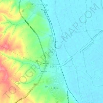
Name: Thourio topographic map, elevation, terrain.
Average elevation: 45 m
Minimum elevation: 21 m
Maximum elevation: 109 m
Thank you for supporting this site ❤️
Make a donation
Make a donation
Other topographic maps
Click on a map to view its topography, its elevation and its terrain.
Pachia Ammos Beach
Greece > Macedonia and Thrace > Evros Regional Unit > Pachia Ammos
Average elevation: 69 m
Samothraki
Greece > Macedonia and Thrace > Evros Regional Unit
Samothraki has a hot-summer Mediterranean climate. Winters are cool and rainy with occasional heavy snowstorms, especially at higher elevations.
Average elevation: 170 m